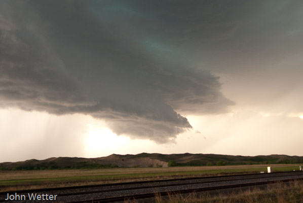
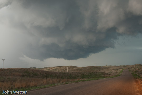
For a marginal day which we all knew it would be, a nice chase. The
storm took on some supercell appearance. It actually looked more
classic than LP. I think the earlier storms moving through really
moistened up the boundary layer.
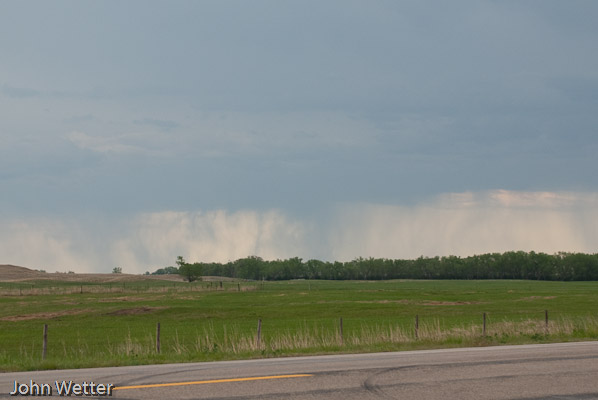
A nice attempt at some rain as we are driving south from Valentine, NE to Thedford.
This is when the storm looked the best, around 7:48pm CDT.
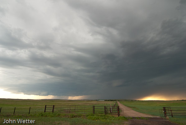
A fairly outflow dominant storm now as it was gusting east of Thedford.
It tried to organize again North of Halsey, NE.
Big Day shaping up on the southern/central plains. No need to look at anything other than the number of chasers all headed to one area. This is going to get interesting once V-2 starts on May 10th……..
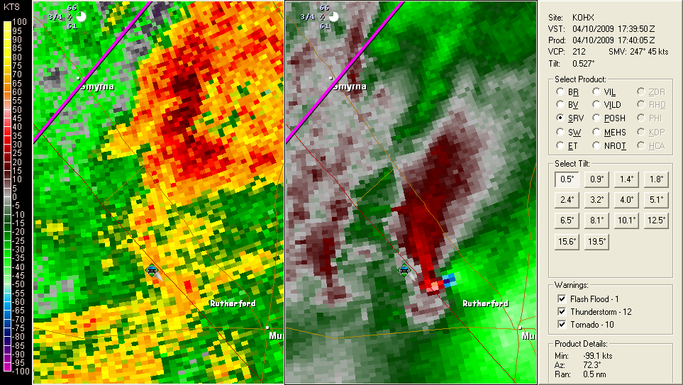
Many tornado warnings and some confirmed tornadoes in Tennessee so far today and more to come likely in the southeast. Here’s one radar grab from the SE of Nashville.

Well, here we are 3 years after Katrina and we have another (currently category 4) hurricane headed for the lower Mississippi. Bands and even the eye of the storm can currently be seen from the Key West, Florida radar.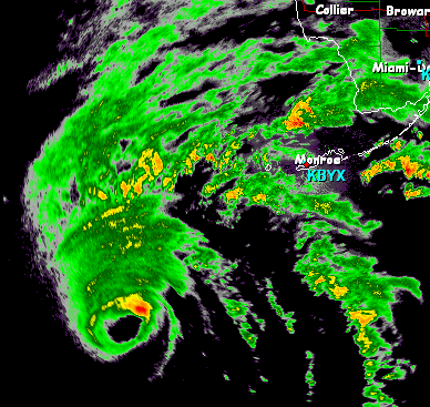
Let’s hope people pay attention to the warnings this time and get outta town. I still wonder when we’ll really ask the question of whether it makes sense to rebuild homes in a bowl that is about 6 feet below sea level right next to the gulf of Mexico. That’s a discussion for some other time.
Either way, stay up to date with Gustav at the NHC.
We’ve had two great days of chasing in Kansas! Thursday we saw several tornadoes, which can be seen in the chase log section of the site or clicking this link. Yesterday, we only saw one tornado as we got caught on the ‘in between’ storms. The storms that went up early produced a wedge tornado that several saw. We saw a nice elephant trunk tornado and then everything went HP (High precipitation) so it was hard to see things and then got dark… On to today!
-John
It looks like tomorrow will be a possibly explosive day in the central plains, with Kansas being under the gun for severe storms. We are just south of Grand Island, NE tonight getting ready for a long day tomorrow. The SPC has a good chunk of Kansas under a moderate risk for severe storms for Thursday. Right now I’m liking an area somewhere from Hill City, down to about Greensburg, KS. Yes, Greensburg is of course the site of the EF-5 tornado last year. You can keep track of us on spotternetwork.org and also on severestreaming.com/livechase
Technical discussion:
The big h5 trof out to our West is starting to eject onto the plains. A Warm front will move northward through the afternoon tomorrow ending up somewhere right around the KS/NE border by early evening. Also, a nice sharp Dryline will be moving east through C KS as well. We’re planning to set up on the nose of the DL as storm motion will be to the north so I’m hoping we can get something to root in the boundary. I think storms will move across the WF too fast to TOR. I’m wondering about the 00Z NAM though as it doesn’t break out any precip on the DL until 6Z, well after dark. Will this be another after-dark monster tornado maker? I’m wondering…. Anyways, I’m also worrying that the h5 winds don’t really veer until around 0z and I think that storms will be going by then… I’m not excited by the hodographs until later in the day, and I worry precip will be going by then. Parameters look otherwise good though. SIGTOR is insane, CAPE is great, LCL’s look good, we just need to winds to work out a bit.
Target:
Hays to La Crosse, KS, possibly needing to move south toward Greensburg.
Well, we have our first slight risk into MN for 2008! The Day3 outlook from the SPC comes up into Central Minnesota. The models have been all over the place the last few days, but this morning brings things together some with actual moisture coming up into the area. The low-level jet comes into the area and the upper jet is in the neighborhood. Looks like we could actually see something coming up here. I’m hoping for thunder at least! I’m not expecting there to really be that much severe weather, but it is looking more likely. The first chase? Maybe.
I’m still out here at WWDC for the rest of the week. Wow, this conference has been eye-opening. A lot of GREAT information so far. My top two presentations so far have been with Directory services (Tiger & Leopard) and also the “from power-on to login” showing all of the processes and the hand-offs. The huge new tool I see for Edu is the Podcast Producer software. This looks to be huge for Edu. I need to play with Leopard more to really get a good feel for how its new architecture will work out. It sure seems to be snappy at this point.
-John
Well, we had a great trip and now we’re back home! I hope everyone had a good time following along as we went!
Thought you guys might be interested in hearing about my chase vacation that
was this last week. We only got one tornado, but saw some great
storms!
One note is that Channel 5 did carry one piece of video:
Video:
http://www.kstp.com/article/stories/S92944.shtml?cat=1&v=1
While they say the tornado didn’t touch down, it actually did just prior to the video shown.
-John
like there was a tornado late tonight well after dark, but nothing really
photogenic in the tornadic department during daylight. I’ve heard a few reports
of tornadoes from people, but I’m not convinced yet… Lots o’ crazy motion
really near the ground, but who knows what goes for a tornado now…
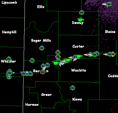
on the storm near Buffalo, OK, that got close to producing a tornado a couple
times. That storm started to look not so great, so we dropped south to Lipscomb
county, TX. Near the city of Lipscomb are where the last half of the pictures
are from. I had to include the one picture of a news helicopter overhead. We
had two of them throughout the chase.
Got in the hotel late last night so didn’t post. We were on the gorgeous supercell near Hill City, KS, along with tons of other chasers. Got great shots, a few of which I poster here:
Yesterday was a driving day, so I didn’t post last night. Right now we’re in Garden City, KS, waiting for things to get started. I’ll update later…
-John & Jamie
We decided to not attempt chasing out here and instead did the rounds in and around Mt. Rushmore. Enjoy the slideshow!
Looks like we’re headed to Nebraska tomorrow…
-John
Getting ready to head out for the plains trip… Man are the models frustrating. This coming week was looking so bad earlier this week that we got a hotel out in the Black Hills for the week so we could get away and do something. I haven’t been out in the hills before, so this would have been a first for me. So, as Crazy goes, both the GFS and the ECMWF are now bringing in a trough by the beginning of the week. Of course, depending on which run you want to believe, I could be chasing in Montana or New Mexico. I’m hoping in the next day or two we get a little more definition… Gotta call and cancel the hotel room…
I’ll try to update this as much as possible this week for everyone who might be watching.
-John
Greetings and welcome to the first of what may turn out to be several posts that I make on a recurring basis. On this page I hope I can get some knowledge out to those who might be reading this and hopefully we’ll all learn something.
You’ll likely see some cross talk on this page between storm chasing, Skywarn, and also some thoughts on education technology, depending on what my mood is. So, I’ll think up some stuff and check back here soon.
Take Care,
John